


Low pressure over BOB concentrates into depression, heavy rain
Low pressure over BOB concentrates into depression, heavy rain
 admin
admin
Bhubaneswar: The regional centre of the India Meteorological Department (IMD) reported on Friday morning that the recent low pressure system that has developed over the Bay of Bengal has become a depression.
In the next six hours, it's likely to worsen into a severe depressive episode.
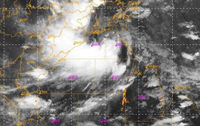
"The low pressure area from yesterday drifted northwest and coalesced into a depression across the northeast and adjacent regions of the east central Bay of Bengal, Bangladesh, and Myanmar coasts. It was located roughly 310 km east-southeast of Balasore, 250 km east-southeast of Digha, and 210 km east-southeast of Sagar Islands at 5:30 am today, according to the Met office. It was centred over the northwest and adjacent northeast Bay of Bengal near latitude 20.5°N and longitude 89.7°E.
"Over the next six hours, it is quite likely to move west-northwestward and strengthen into a deep depression. It is anticipated that, if it keeps moving in the same direction, it would pass between the Balasore and Sagar Islands and the shores of West Bengal and Odisha this evening. After making landfall, it will continue moving west-northwest across north Odisha, West Bengal, and Jharkhand toward north Chhattisgarh before gradually weakening, according to the forecast.
The system could strengthen into a cyclone, according to the Joint Typhoon Warning Center (JTWC) of the US.
IMD DG Mrutyunjay Mohapatra stated that a red alert has been issued for Odisha and that the state is anticipated to experience heavy rains from August 19 through 20. Odisha's north and west are anticipated to be impacted. He continued, "Upcoming rains may further exacerbate the flood situation in the state."
Red warning: Keonjhar and Mayurbhanj districts are likely to have isolated extremely heavy falls (>20 cm), as well as moderate to very heavy rainfall (7 to 20 cm) in a few locations.
Orange warning: It's expected that some locations in the Kendrapara, Jagatsinghpur, Cuttack, Dhenkanal, Angul, Deogarh, Sundargarh, Sambalpur, Sonepur, Boudh, Balangir, Jajpur, Balasore, and Bhadrak districts will see heavy to very severe rainfall (7 to 20 cm).
Yellow warning: Isolated areas in the Jharsuguda, Bargarh, Kalahandi, Kandhamal, Nayagarh, Khurda, and Puri districts are very likely to see heavy rainfall (7 to 11 cm).