


Another low pressure system forms in the Bay of Bengal after Cyclone Asani
Another low pressure system forms in the Bay of Bengal after Cyclone Asani
 admin
admin
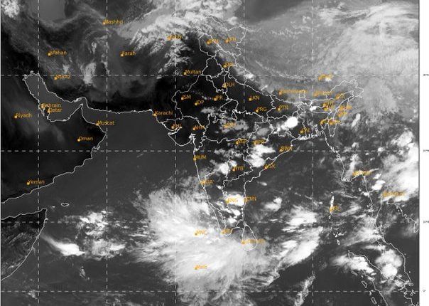
Bhubaneswar: Even as Odisha breathed a sigh of relief after escaping the ferocity of cyclone Asani, another low-pressure region is expected to form over the central Bay of Bengal by May 19, according to an extended forecast from the India Meteorological Department.
"In a day or two, the system is predicted to enter the South Andaman Sea and develop into a low-pressure region," an IMD official said.
Late next week, senior meteorologist Jason Nicholls tweeted about the prospect of low pressure over the northeast Bay of Bengal, which is part of the monsoon trough. He continued, "Most likely tracks look NE into Myanmar."
Due to strong westerly and southwest monsoons, a low may develop in westcentral Bay and southwest Bay, move north-northeast into Odisha-Andhra Pradesh for about 24 hours, and then towards Myanmar, according to meteorological expert Sandeeep Patnaik.
In the next 48 hours, the IMD predicts the onset of the Southwest monsoon, with the system moving into the South Andaman Sea and bordering Southeast Bay of Bengal. It is expected to hit Kerala on May 27 and then go to Odisha for another 10 to 12 days.
During the next 24 hours, the Met Office predicts thunderstorms with lightning and gusty surface winds of 30-40 kmph in one or two places over the districts of Deogarh, Angul, Dhenkanal, Keonjhar, Mayurbhanj, and Balasore, as well as thunderstorms with lightning in one or two places over the districts of Koraput, Malkangiri, Nabarangpur, Nuapada, Gajapati, Rayagada, Kand